Showing posts with label New Mexico. Show all posts

Saturday, October 9, 2021

November 18, 2019 - Underground New Mexico

I woke at 3:30 to a fairly clear 47º morning, and as I couldn’t get back to sleep, got up, ate breakfast, and got on the road by daybreak.  As one drives through west Texas, there’s no doubt that Oil is the basis of the economy here.


I don’t know how much natural gas is burned off (wasted?) here, but almost every facility is sporting a perpetual flame.

I drove on into New Mexico, with an eye to visit part of America that I’d never seen before.
Deep beneath the Chihuahuan Desert in southern New Mexico is a labyrinth of more than 300 limestone caves, carved over 250 million years ago, and since I was in the vicinity, it was time to visit the Carlsbad Caverns National Park.

At 9 a.m., I pulled into the Caverns, getting in “free” with my ”America the Beautiful - The National Parks and Federal Recreational Lands Senior Pass”, which costs $20 a year or $80 for a ‘lifetime’.

I watched the 15-minute introductory video, and then embarked on the self-guided tour, having rented the self-tour guide for $5.  Although this Park gets around a half-million tourists visiting every year, there were few enough on this November morning to allow for a pleasant visit.

On the walk to the natural entrance, there were several interpretive signs for the visitors, and I always enjoy learning a little about the local natural history.

The Algerita (Mahonia trifoliolata) was used by the indigenous people for food (berries), medicine (a concoction used to treat sores), and a yellow dye was made from the roots.

Another sign noted the seeds of the Catclaw Acacia (A. greggii) were ground into a meal called pinole, and made into cakes or eaten as a mush.  The native bees gather nectar when its yellow flowers bloom.  I enjoy seeing the various species of acacia, as I remember “A Sprig of Acacia” that features in an old story known to those with eyes to see and ears to hear.

At the entrance to the cave, there’s a warning sign about Radon.  Radon is a radioactive, colorless, odorless, tasteless noble gas that is reported to be carcinogenic.  There seems to be quite an industry built up around testing homes for radon, costing about $75-200.  For the same price, you can buy your own radon detector . . .

Thousands of Mexican freetail bats use the cave, and the interpretive signs happily let us know about them.  This being November, most of the Caverns’ bats have decided to winter south into Mexico.  The best time to see them might be in August or September, when daybreak or sunset flights are said to be pretty neat!

The entrance to the cave is paved and easy to traverse.

The old entrance was certainly more challenging, and there are remnants of the old ladders and staircases in the caverns.  There are still wooden stairs that originally took people down a different way until the “iceberg rock” detached and fell crushing the stairs and necessitating a new entrance.

I presume that the Park Service leaves the old stairs, etc. in situ because they now have “historical significance”.


Carlsbad Cavern includes a large cave chamber, the Big Room, a natural limestone chamber which is almost 4,000 feet (1,220 m) long, 625 feet (190 m) wide, and 255 feet (78 m) high at the highest point.  It is said to be the third largest chamber in North America and the seventh largest in the world.  There are certainly lots of things to see here.

I did not find out what caused the green layer on this speleothem column.  In some caves there are impurities of glauconite, an iron potassium phyllosilicate with a green colour.  Or, because the Caverns are subtly lighted for the tourists, it could well be caused by algae growth on the calcite.


Whether you are a Cave Junkie, or never give karst caves a second thought, you can’t help but be amazed at the beauty of the formations.

Of course, people have given cute names to many of the dripstones and flowstones.  This one’s the “Whale’s Mouth”, ostensibly because the folds in the rock look like baleen.

A block of solid gypsum is impressive for those of us who got decent grades in our Geology classes.

The water in the cave is crystal clear.  I attempted a picture of some pools with neat little rimstone dams, but between my camera and my ‘droid phone being challenged by the low lighting, you’ll just have to visit here yourself to see those.

I did not take a flashlight, but used the light on my cell phone here and there to view some of the features; I think a really bright light would have detracted from the (my) experience.  It is probably a good idea to take a light jacket, especially in the summer when the difference between the surface heat and the cool underground would be pretty great.  The temperature of the Big Room of Carlsbad Cavern, at a depth of 750 feet (about 230 meters) below the surface, is 56°F (13°C).

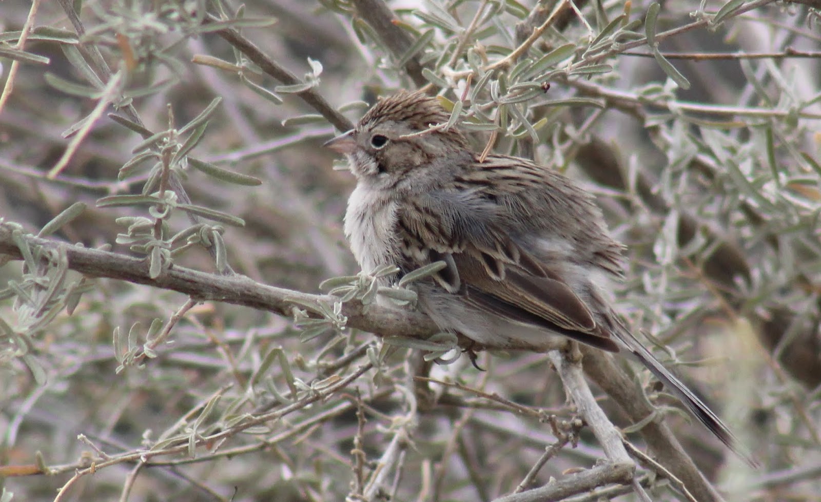
Dropping off the audio guide, I left the Caverns and took the Desert Drive, seeing a few Scaled Quail.  I tooled across the Guadalupe and Sacramento Mountains to Cloudcroft, checking into the Summit Inn among the pines and firs in the Lincoln Natl. Forest.

I suppered with a green chili cheeseburger and a couple pints at Dave’s Café.  They seem to run a friendly, local place that made me feel at home.  I’d eat here again.

Carlsbad Caverns Desert Drive eBird Checklist is Here


Sunday, May 5, 2019

April 20 - New Mexico


I ate at the motel; scrambled egg pieces and sausage patties.  Then, I left town and drove up to Dalhart, then across Highway 102 west toward New Mexico, en route toward home.  I stopped to check the birds at an abandoned farmstead, and then at a prairie dog town where I found a pair of Burrowing Owls.
There's an owl!
There were two, when I got the scope on them
I stopped to do a little birding at the Ute Creek Bridge, and a rancher came over to talk.  I imagine that he appreciated the chat, as Harding County only has a population of 665 people!  As I drove west, I spied this wonderful church building.  Bueyeros is almost dead center in the wide-open grassland that stretches across northeastern New Mexico.  Beyond a few ranch houses, the most amazing structure is the Sacred Heart Church - dating from 1894 - one of the most remote churches in northeastern New Mexico.  This church was built on a French design, and has a turquoise and copper steeple.  I read in Historic Churches in New Mexico Today, by Frank Graziano, that parishioners gather at the base of Dead Man’s Butte around the feast day of Santiago on July 25, to celebrate La Misa del Cerro - to pray for rain.
Sacred Heart of Jesus Church in Bueyeros, N.M.
I continued west, stopping to check out a hawk nest, that turned out to host a Ferruginous.
Then I drove through the Carson Natl. Forest and stopped on the Corazon Hill summit to view the wide open spaces.
This Country Is Full!
There is a city of Las Vegas in New Mexico, much less glitzy than the one in Nevada.  And, there is a National Wildlife Refuge near town.  I spent some time birding around the Headquarters (which was closed) and entrance road, and around past the McAllister Lake Wildlife Management Area.
This Pond Needs Water
Stopping at the NWR’s Gallinas Canyon trail, I walked out to the head of the cañon and viewed the ruins of the old ranch.
A Rock Wren kept an eye on me

Arriving in Taos, I checked into the Super 8.  Clean and relatively inexpensive; I signed up for their ‘frequent flyer’ program.  Vanessa, the desk clerk, suggested the Old Martina's Hall for supper, and I found it to be a wonderful place.  I had the Red Ruby Trout and a couple Santa Fe Pale Ales for $30.  The trout had a ‘sauce’ of tomato and capers that were spiced just right.

Abandoned Farmstead eBird Checklist is Here
Prairie Dog Town eBird Checklist is Here
Ute Creek Bridge eBird Checklist is Here
Las Vegas NWR eBird Checklist is Here
McAllister Lake WMA eBird Checklist is Here
Gallinas Canyon eBird Checklist is Here

Saturday, March 9, 2019

February 15 - New Mexico

I woke at 5:45 to a cloudy 49° morning, and had a cup of coffee and ate an apple for breakfast.  I drove east on I-40 to the Tijeras exit, then took Highways 14 and 536 to Sandia Crest, getting there around 9 a.m. by following the snow plow and sanding truck.  My goal there was to find a flock of Rosy-Finches.The crest is at 10,678 feet elevation, which made for short breath for this boy, who normally lives at sea level!
Elevation 10,678 feet (3,255 meters)
The morning was mostly clear, but just at freezing, with a bit of a west wind.
There was a great view out across Albuquerque
I walked around the Sandia Crest House, and found where they have been setting out seed, with only a few Mountain Chickadees coming to the feed.
I walked over toward the radio towers at the crest, but saw no birds there.
 
After about a half-hour, another car showed up, with birder Nancy Moore from Boise and her daughter (Jenna – grad student at UNM doing a genetic review of the Coraciids) who were also looking for the finches.  Another couple from Michigan showed up as well, with the same intent.  We had to be careful around the crest, because of the icy trails.
 
We were watching a feeder just above the parking lot, and had about given up hope, when a flock of nearly 60 finches came swirling in, with most disappearing around the back of the buildings from us.
I did get a good view of two birds that perched briefly on the roof, and they were both Black Rosy-finches.  We all spent a while longer waiting for the birds to come to the upper feeder area, and had a couple finches come to the deck of the building, but then dropped back down the steep slope.
I got a decent view of a Brown-capped Rosy-finch, but it didn’t stick around for photos.  Finally, I got a decent shot of one of the Black Finches.  I waited around until about 11:30 hoping for the finch flock to return, but to no avail.
Lifer Black Rosy-finch
I dropped back down the mountain, stopping at the Triangle Grocery in Cedar Crest to buy some travelling food.  Then, I headed down the highway to the Bosque del Apache National Wildlife Refuge.  This is a 57,330 acre unit with a Visitors’ Center and a couple of auto tour routes, besides having a number of trails.
I stopped at the Center to enquire about a Winter Wren that had been seen there a few days ago.  Somehow, I have missed seeing - or at least recording - Winter Wren since I was working at Horicon Refuge in Wisconsin back in 1978.  So, I thought that this might be an opportunity to ‘tick’ the species before I go east later in the year.  The folks gave me good directions to where it had been seen, along the North Auto Tour route.  I didn’t make it far at first, because this Refuge provides feeders at the center, and in their cactus gardens.
I spent a bit of time strolling and sitting, and enjoying the birds here.
White-winged Dove
Brewer's Sparrow
Harris' Sparrow
Gambel's White-crowned Sparrow
At the auto tour route, there was a traffic jam of people watching a large flock of Snow Geese.
Only a few of these were the “Blue Goose” color morph, which are more common to the east.
I found, through the telescope, a few Ross’ Geese mixed in the sea of white.
The North Route, is what they used to call the “Farm Route”, as the road goes past the agricultural fields.  The Refuge plants corn and other crops to feed the birds through the winter.
I spent ‘way too much time on the loop, at first just looking - unsuccessfully - for the wren, and then just being mesmerized by the thousands of Sandhill Cranes

and the other wildlife.
I left at dark, and it was too late to go south, so I went back to Socorro and checked into an “America’s Best Value Inn” for $50.  The room was clean, and well-lit, but the promised Internet connection was terrible.  At least it didn’t cost extra . . .

Sandia Crest eBird Checklist is Here

Bosque del Apache Visitors’ Center eBird Checklist is Here

Bosque del Apache north auto tour eBird Checklist is Here